 A dangerous nor'easter is forecast to hit Columbia County Monday night through the day on Tuesday. This storm is expected to bring very heavy snowfall and blustery winds. Wind gusts up to 30 mph will cause blowing and drifting snow and whiteout conditions. Please, make arrangements now to stay off the roads on Tuesday.
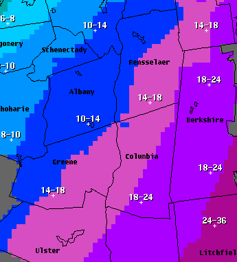
Here is the latest update from Columbia County 911: **STORM UPDATE** WINTER STORM WARNING issued for Columbia County, effective 1:00 PM tomorrow through 1:00 AM Wednesday (Jan 28)... this upgrades the previously issued "Watch”... accumulations are now being forecast in feet, with 1 to 2 feet expected across all of Columbia County... worst conditions are expected Monday night through the day on Tuesday when we could see snowfall rates of 2”-3” per hours and wind gust of 30 mph. As is often the case, a slight shift in the track of this storm could make a big difference on conditions here.... so please pay attention to updates and forecasts. ----STORM SUMMARY AS OF 5:00 PM SUNDAY---- * SNOW ACCUMULATIONS...12 TO 24 INCHES (12" RANGE NORTHWESTERN COLUMBIA COUNTY, 24" RANGE IN SOUTHEASTERN COLUMBIA COUNTY - SEE ACCUMULATION FORECAST GRAPHIC) * MAXIMUM SNOWFALL RATES...2 TO 3 INCHES PER HOUR. * TIMING...SNOW WILL OVERSPREAD THE REGION FROM SOUTHWEST TO NORTHEAST MONDAY AFTERNOON AND WILL CONTINUE HEAVY AT TIMES MONDAY NIGHT INTO TUESDAY BEFORE GRADUALLY TAPERING OFF LATE TUESDAY NIGHT. * IMPACTS...EXTREMELY DANGEROUS TRAVEL CONDITIONS DUE TO SNOW COVERED ROADWAYS AND LOW VISIBILITY. BLOWING AND DRIFTING SNOW WILL ALSO BE LIKELY. SOME ROADS MAY BECOME IMPASSABLE. * WINDS...NORTH 10 TO 20 MPH WITH GUSTS UP TO 30 MPH. * TEMPERATURES...IN THE TEENS TO LOWER 20S. *PRECAUTIONARY/PREPAREDNESS ACTIONS... SIGNIFICANT AMOUNTS OF SNOW ARE FORECAST THAT WILL MAKE TRAVEL DANGEROUS. ONLY TRAVEL IN AN EMERGENCY. IF YOU MUST TRAVEL...KEEP AN EXTRA FLASHLIGHT...FOOD...AND WATER IN YOUR VEHICLE IN CASE OF AN EMERGENCY.
1 Comment
Leave a Reply. |


Archives
April 2022
Categories
All
|
 RSS Feed
